
Ranked by fatal traffic crashes, 2018 to 2023. Source: federal crash data.
Between 2018 and 2023, 527 people were killed in traffic crashes in Milwaukee County. Those deaths were not spread evenly across the map. A small number of roads carried a large share of them. Using six years of federal crash records, this page ranks the roads where fatal crashes happened most often, so drivers, families, and local leaders can see the pattern clearly.
We handle the cases behind these numbers, so we built this from the public data rather than the headlines. Here is what six years of it shows.
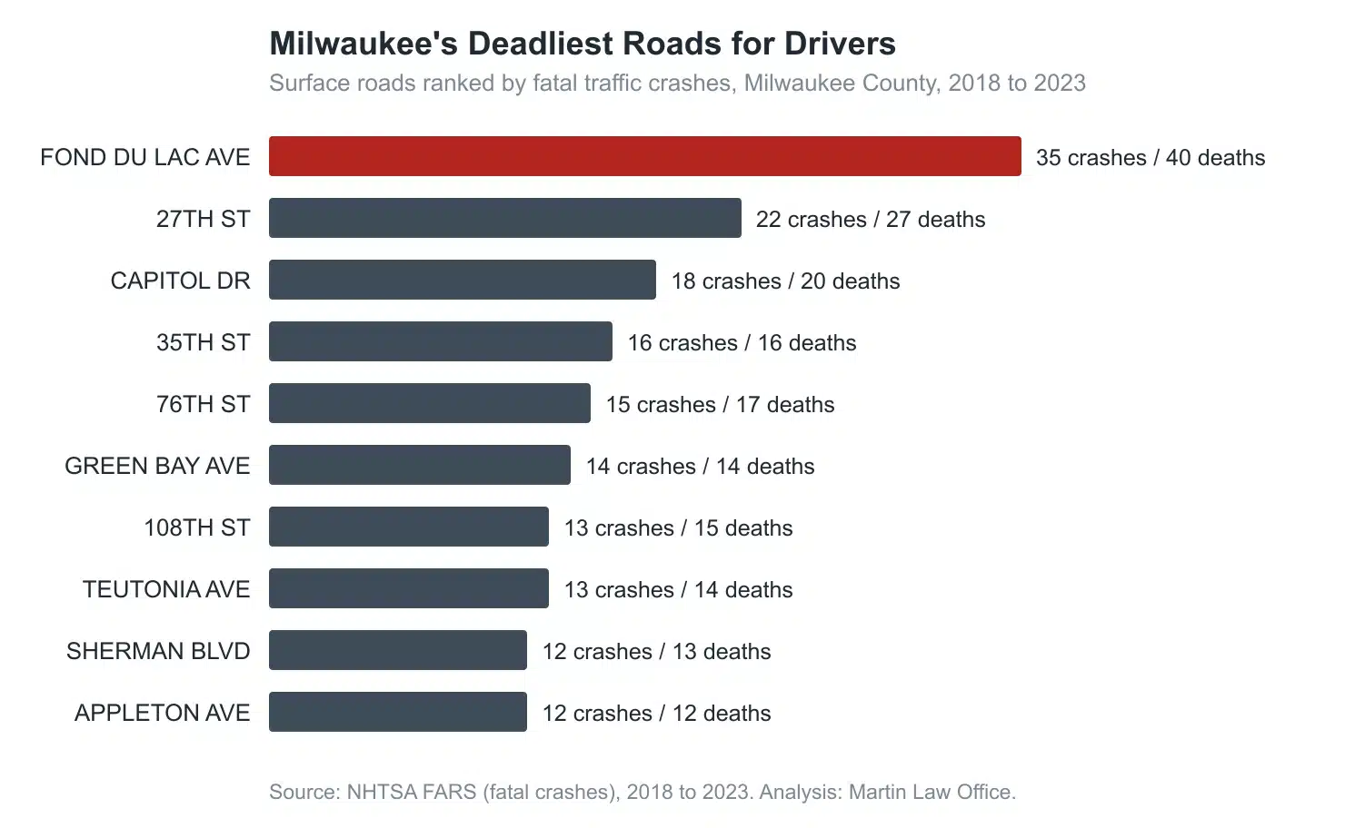
These are the local roads with the most fatal crashes from 2018 to 2023. Several are state highways that carry a local street name, shown in parentheses.
| Rank | Road | Fatal crashes | Deaths |
|---|---|---|---|
| 1 | Fond du Lac Avenue (WI-145) | 35 | 40 |
| 2 | 27th Street (with WI-241) | 22 | 27 |
| 3 | Capitol Drive (WI-190) | 18 | 20 |
| 4 | 35th Street | 16 | 16 |
| 5 | 76th Street (with WI-181) | 15 | 17 |
| 6 | Green Bay Avenue (WI-57) | 14 | 14 |
| 7 | 108th Street (WI-100) | 13 | 15 |
| 8 | Teutonia Avenue | 13 | 14 |
| 9 | Sherman Boulevard | 12 | 13 |
| 10 | Appleton Avenue (WI-175) | 12 | 12 |
Many of these are long, high-traffic arterials that run for miles through dense neighborhoods, mixing fast-moving cars with pedestrians, cyclists, buses, and cross traffic. That combination, repeated over thousands of trips a day, is where most of the county’s fatal crashes happened.
Limited-access freeways are ranked separately, since they carry very different traffic than surface streets.
| Rank | Freeway | Fatal crashes | Deaths |
|---|---|---|---|
| 1 | I-41 | 15 | 15 |
| 2 | I-43 | 12 | 16 |
| 3 | I-94 | 9 | 10 |
| 4 | I-794 | 4 | 5 |
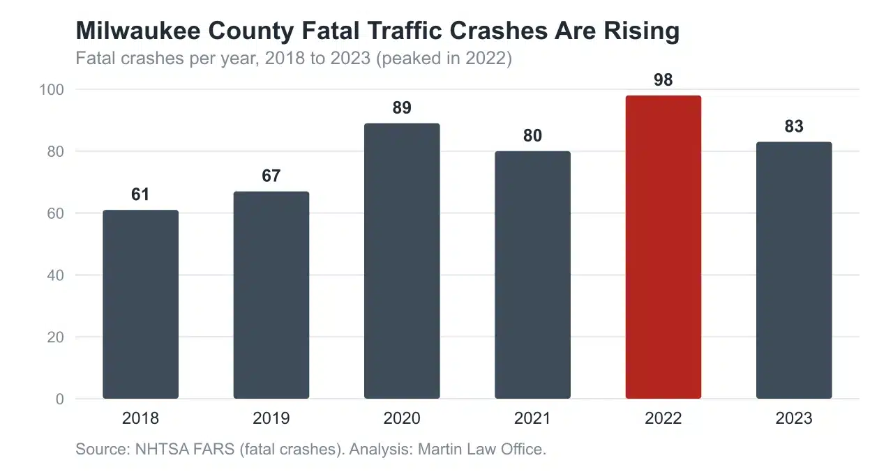
The six-year trend is the part that should concern every driver in the county. Fatal crashes climbed from 61 in 2018 to 98 in 2022, a 61 percent increase, before slipping to 83 in 2023. The 2020 jump is notable because overall traffic fell during the pandemic, yet fatal crashes rose, a pattern seen nationwide and tied to higher speeds on emptier roads.
Two facts stand out. First, the deaths cluster on a short list of arterials: the top five roads alone account for nearly a quarter of every traffic death in the county. Second, they cluster geographically: 394 of the 478 fatal crashes happened within the city of Milwaukee, with the remainder spread across West Allis, South Milwaukee, Wauwatosa, Greenfield, and the other suburbs.
For drivers, the practical takeaway is simple. The roads on this list are not unusual because they are unsafe by design. They are the busiest, longest, fastest arterials in the region, and the volume is what drives the crash counts. Extra caution on Fond du Lac, 27th, Capitol, 35th, and 76th is time well spent.
Behind every figure on this page is a person and a family. When a fatal crash is caused by another driver’s negligence, Wisconsin law allows the surviving family to bring a wrongful death claim for their loss, and injured survivors of serious crashes may have a car accident claim of their own.
These cases turn on evidence: crash reconstruction, medical records, and the specific facts of what happened. Martin Law Office was founded by Kevin R. Martin, a registered nurse and dual board-certified trial lawyer, which lets our team read the medical and physical evidence in a crash the way few firms can. We represent injured people and grieving families across Milwaukee, West Allis, Greenfield, and the greater Milwaukee area.
If you or someone you love was hurt or killed in a crash on one of these roads or anywhere in southeastern Wisconsin, our attorneys can help you understand your options. Contact Martin Law Office for a free case consultation. No fee unless we win.
Journalists, researchers, and safety advocates are welcome to cite or republish this analysis with attribution. Please credit Martin Law Office, “Milwaukee’s Deadliest Roads for Drivers” (2026), based on NHTSA FARS data, with a link to this page.
Last updated: July 2026.